The Stormy Southwest Pacific
NASA ·
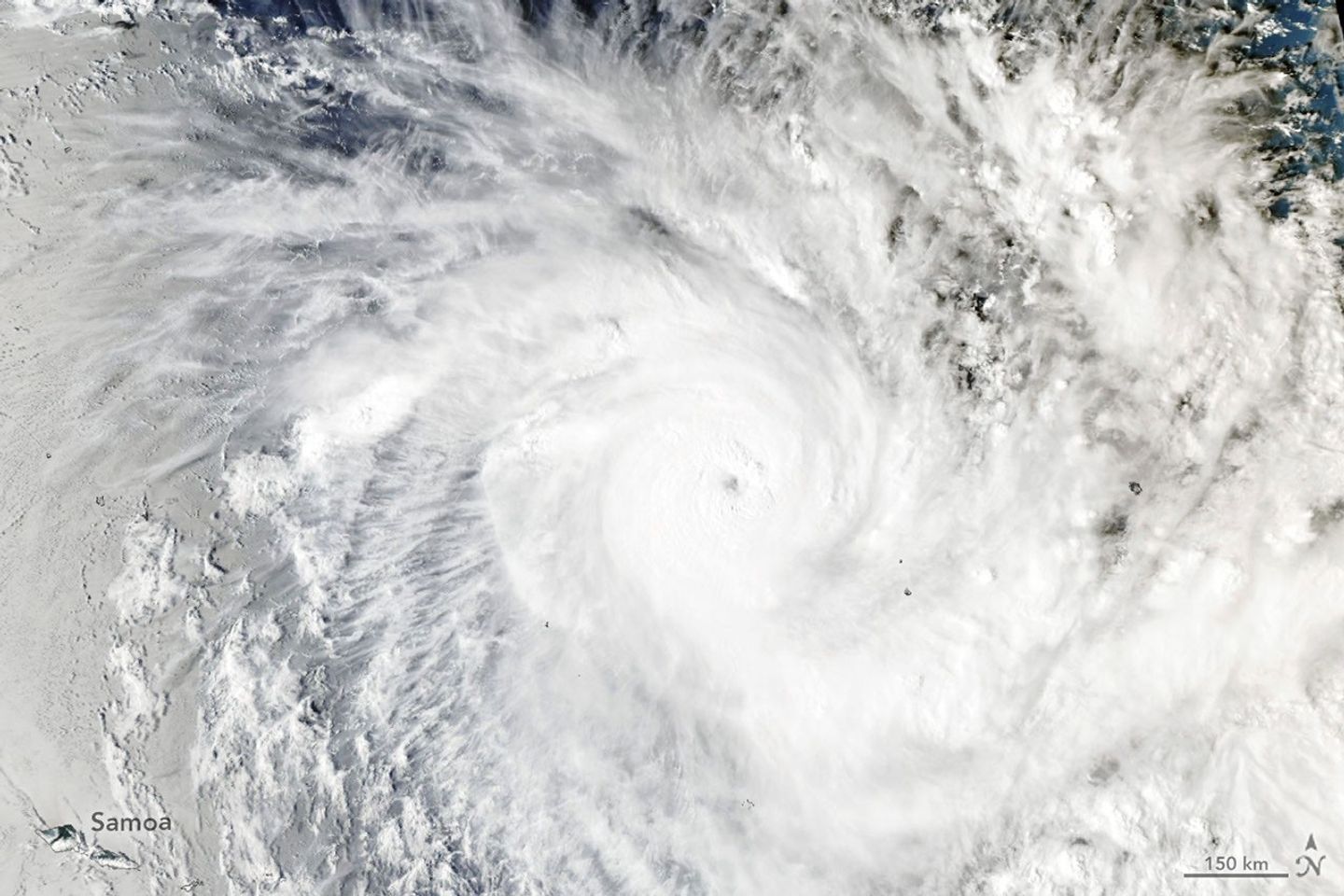
Tropical Cyclone Xavier launched the basin’s storm season with a bang.
All Topics Atmosphere Land Heat & Radiation Life on Earth Human Dimensions Natural Events Oceans Remote Sensing Technology Snow & Ice Water More Content Collections Global Maps World of Change Articles Earth Matters Blog Blue Marble: Next Generation EO Kids Mission: Biomes About About Us Subscribe 🛜 RSS Contact Us Search Even as the unusually quiet 2026 storm season winds down in the North Atlantic, seas have begun to stir on the other side of the world in the Southwest Pacific. On November 15, 2026 , the Fiji Meteorological Service began issuing updates about a slow-moving tropical disturbance northeast of Samoa and the Cook Islands. Within just a few days, it had become one of the most intense November tropical cyclones the region has seen in decades.
Named Xavier , the system intensified rapidly , thriving in an environment with minimal wind shear and sea surface temperatures of 29 degrees Celsius (84 degrees Fahrenheit)—well above the threshold required to sustain and strengthen developing tropical cyclones . Xavier was the basin’s second named storm of the season, following only Wati , a short-lived storm that emerged in October.
As Xavier developed, NASA satellite data showed the storm churning along the southwestern edge of a massive tongue of warm water spanning from the west coast of South America to the central Pacific—a telltale sign of the El Niño that has been present in the region since June .
When the MODIS (Moderate Resolution Imaging Spectroradiometer) on NASA’s Aqua satellite captured this image at 02:53 Universal Time on November 17, 2026 (4:53 p.m. Cook Islands Time on November 16), forecasters estimated Xavier had maximum winds of about 195 kilometers (120 miles) per hour. Winds reached a peak intensity of 220 kilometers (140 miles) per hour later that day, a Category 5 storm on the cyclone intensity scale used in the region or a Category 4 on the Saffir-Simpson scale .
The storm ranks as the strongest November tropical cyclone east of the international date line on record, noted Colorado State University hurricane expert Phil Klotzbach . Xavier’s formation east of the date line, near the northern Cook Islands, was unusual, but its easterly position aligns with research that indicates that storm activity in the region typically shifts northeast during El Niño years. Research also shows that El Niño tends to fuel storms that strengthen at an unusually rapid pace .
According to news reports, Xavier damaged homes and caused power disruptions as it passed the northern Cook Islands. It then encountered dry air and a less favorable wind shear environment and slowly weakened as it pushed westward, reducing the threat that it posed to Samoa and American Samoa.
Xavier is likely one of the first of several storms to affect the region in the coming months. A seasonal outlook from the Fiji Meteorological Service projects that the region could see between 11 and 15 named tropical cyclones this season, with the greatest risk east of the international date line. Storm activity in the Southwest Pacific basin typically peaks in February .
NASA Earth Observatory image by Lauren Dauphin, using MODIS data from NASA EOSDIS LANCE and GIBS/Worldview . Story by Adam Voiland.
JPEG (1.52 MB)
Stay up-to-date with the latest content from NASA as we explore the universe and discover more about our home planet.
Several ingredients came together off the Pacific coast of Mexico to generate one of the strongest storms the eastern Pacific…
Article
The powerful storm delivered extreme rainfall and damaging winds to the state, passing the Island of Hawaiʻi as a category…
Article
Super Typhoon In-fa developed an unusually large eye, and the remnants of Typhoon Champi transitioned into an extratropical storm that…
Article
Subscribe to the Earth Observatory and get the Earth in your inbox.
NASA’s Earth Observatory brings you the Earth, every day, with in-depth stories and stunning imagery.
Explore Earth Science
Open access to NASA’s archive of Earth science data